|
|
|
|
|
|


 |
|||
| Product Main Page | |||
| Key Features | |||
| System Requirements | |||
| Documentation | |||
| Downloads | |||
| Support | |||
EASy 3.50
Key Features
- Specifically designed for marine applications
- Instant web deployment
- Access to spatial and temporal dimensions
- Relational database-driven environment
- Advance modeling functionality and data analysis tools
- Handles a wide variety of oceanographic data formats
Handles a wide variety of oceanographic data formats
EASy handles a wide range of formats for raster images,
vector representation including DXF and shapefiles. Thus, most data from
other types of GIS software (such as ESRI’s products) can be imported.
The software also facilitates broad, platform independent access to data,
integrated visualization products and analytical tools over the Internet
via Netviewer. It also features advanced automated downloading of new
data sets, such as daily satellite imagery. EASy can integrate audio and
video information. It provides a most friendly interface for importing
a diverse range of formats
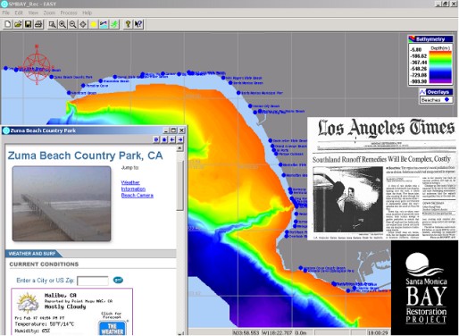
EASy can handle a variety of file formats, without requiring any plug-ins, and as well, EASy can integrate with multimedia files: ideal for education and public outreach programs.
